
Malenadu Travel
Malenadu rivers begin as small streams in rain-soaked hills and grow into the rivers that water half of Karnataka. This guide follows ten of them, from the Tunga, Bhadra and Sharavathi to the Kali, Aghanashini and Kaveri: where each one rises, where it flows, the dams on it, the life in it and how to stay safe near it in the monsoon.
On this page
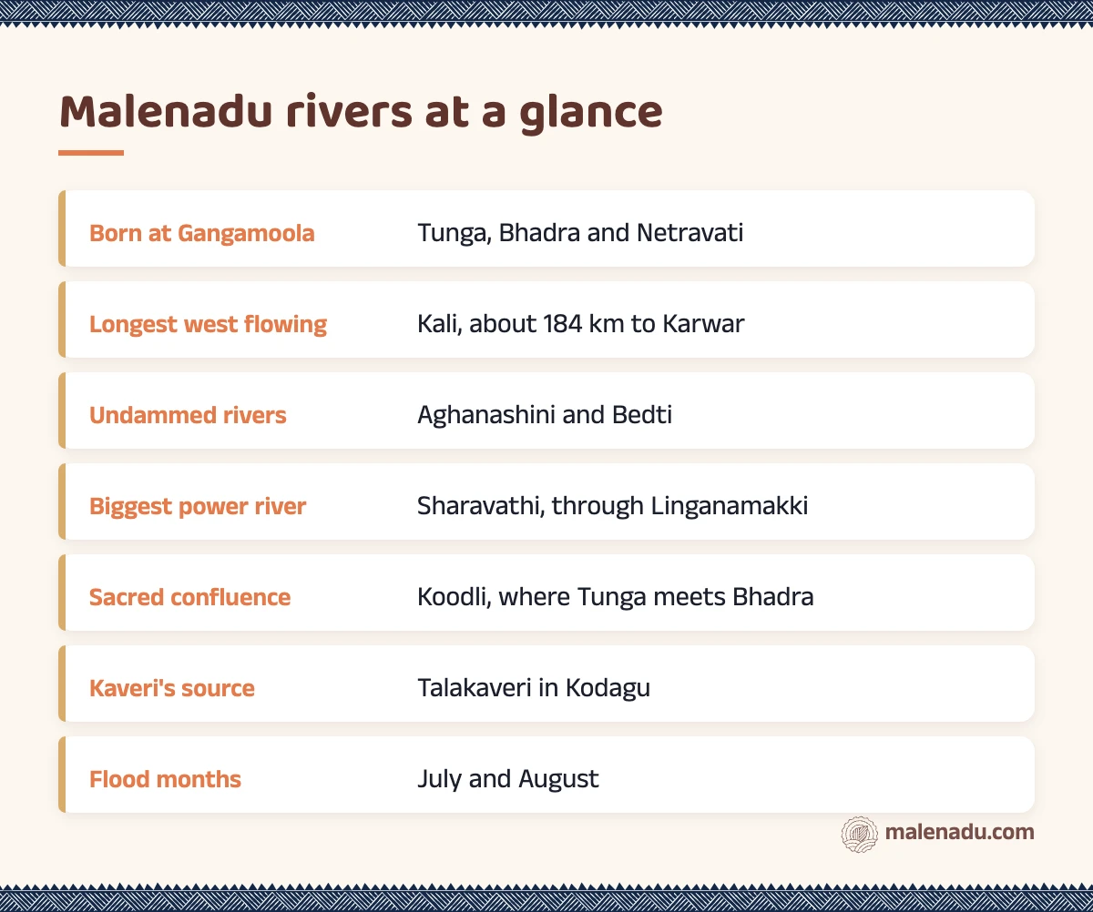
What are the main Malenadu rivers and where do they rise?
The main Malenadu rivers are the Tunga, Bhadra, Sharavathi, Varahi, Kali, Aghanashini, Bedti, Netravati, Hemavathi and Kaveri. All ten rise in or near the Western Ghats of Karnataka, where the monsoon dumps rain on steep, forested hills. Some race west to the Arabian Sea in a short distance. Others turn east and travel hundreds of kilometres across the Deccan.
Every Malenadu town sits beside one of these rivers or a stream that feeds them. If you are new to the region, start with our guide to Malenadu in Karnataka, which has a short section on its rivers. The table below gives the basics for each river.
| River | Rises at | Flows through | Ends at |
|---|---|---|---|
| Tunga | Gangamoola, Kudremukh hills | Sringeri, Thirthahalli, Shivamogga | Joins the Bhadra at Koodli |
| Bhadra | Kudremukh hills near Gangamoola | Kalasa, Horanadu, Bhadravathi | Joins the Tunga at Koodli |
| Sharavathi | Ambutirtha, Thirthahalli taluk | Linganamakki, Jog, Gerusoppa | Arabian Sea at Honnavar |
| Varahi | Hebbagilu near Agumbe | Kunchikal, Halady, Basrur | Arabian Sea near Kundapura |
| Kali | Diggi, Joida taluk | Supa, Dandeli, Kadra | Arabian Sea near Karwar |
| Aghanashini | Manjuguni near Sirsi | Unchalli, the Kumta coast | Arabian Sea at Tadri |
| Bedti (Gangavali) | Near Dharwad and Hubballi | Kalghatgi, Magod, Yellapur forests | Arabian Sea near Ankola |
| Netravati | Kudremukh hills | Dharmasthala, Uppinangady, Bantwal | Arabian Sea at Mangaluru |
| Hemavathi | Javali, Mudigere taluk | Sakleshpur, Gorur, Hassan district | Joins the Kaveri near Krishnarajasagara |
| Kaveri | Talakaveri, Brahmagiri hills | Bhagamandala, Kushalnagar, Mysuru plains | Bay of Bengal |
Why do some Malenadu rivers flow west and others east?
Malenadu rivers flow west or east depending on which side of the Western Ghats crest they start. The crest runs north to south through the region like a roof ridge. Rain that falls on its western face runs quickly down to the coast, while rain on the eastern face drains slowly across the plateau towards the Bay of Bengal.
West flowing Malenadu rivers
The west flowing Malenadu rivers are short, steep and fast. The Sharavathi is only about 130 km long, yet it drops from the hills to sea level and makes Jog Falls on the way. These rivers carry huge floods in July and shrink sharply by April. Near the sea they widen into estuaries lined with mangroves, coconut palms and fishing boats.
East flowing Malenadu rivers
The east flowing Malenadu rivers are long and gentle once they leave the hills. The Tunga and Bhadra become the Tungabhadra, which flows past Hampi and finally joins the Krishna. The Hemavathi joins the Kaveri, which irrigates paddy all the way into Tamil Nadu. A single monsoon storm over Malenadu can raise water levels in reservoirs far out on the plains.
This split is why the rivers originating in Western Ghats Karnataka matter to so many people. Farmers in dry districts hundreds of kilometres away depend on rain that fell on a Malenadu hilltop weeks earlier.
Gangamoola: where the Tunga, Bhadra and Netravati begin
Gangamoola is a hill in the Kudremukh range of Chikkamagaluru district where three Malenadu rivers are born: the Tunga, the Bhadra and the Netravati. It stands about 1,458 m above sea level and is also called Varaha Parvata. A cave on the hill holds an old image of Varaha. A small shrine to the goddess Bhagavathi marks the spot where the streams begin.
The hill lies inside Kudremukh National Park, so you cannot simply drive up and walk to the springs. Treks in the park need Forest Department permission and a guide. Some routes stay closed for long periods. Read our Malenadu trekking guide before you plan a visit.
What makes Gangamoola special is how quickly its three streams part ways. The Tunga and Bhadra head east and meet again near Shivamogga. The Netravati turns west and runs down to Mangaluru. Rain falling a short walk apart on the same hill can end up in two different seas.
Tunga and Bhadra: the twin rivers of Malenadu
The Tunga and Bhadra are the best known pair among Malenadu rivers, two rivers that rise together at Gangamoola and meet again at Koodli. People say “Tunga paana, Ganga snaana”, meaning drink from the Tunga and bathe in the Ganga, because Tunga water is famous for its sweetness.
The Tunga
The Tunga flows past Sringeri, where the temple steps lead straight into the river. It then runs through Thirthahalli, a river town where the Tunga bends below the old bridge (see our Thirthahalli guide). A barrage at Gajanur near Shivamogga holds back water for irrigation before the river passes through Shivamogga city.
The Bhadra
The Bhadra runs through Kalasa and past the Annapoorneshwari temple at Horanadu, deep in coffee and areca country. The Bhadra dam at Lakkavalli, commissioned in 1965, creates a large reservoir surrounded by the Bhadra Tiger Reserve. Below the dam the river flows through the steel town of Bhadravathi.
Koodli, where the two meet
At Koodli, a village near Shivamogga, the Tunga and Bhadra join to become the Tungabhadra. The confluence is held sacred, with old temples on the bank and a small shrine marking the meeting point. It is a quiet place to sit by water that started at Gangamoola days earlier.
The Sharavathi river: Linganamakki, Jog and the sea at Honnavar
The Sharavathi river rises at Ambutirtha in Thirthahalli taluk and runs about 130 km to the Arabian Sea at Honnavar. According to the IISc Energy and Wetlands Research Group, it has two major dams with power stations, Linganamakki and Gerusoppa. A third dam at Talakalale sits on the same system.
The Linganamakki reservoir near Sagara is one of the largest bodies of water in the state, with flooded valleys and islands of forest. Below it, the river leaps about 253 m at Jog Falls. Our Malenadu waterfalls guide covers Jog and the other falls in detail, so we will not repeat them here.
The lower Sharavathi valley is a sanctuary for the lion-tailed macaque. Its forests also hide Myristica swamps, which we describe further down. At Honnavar, close to where we are based, the river meets the sea in a wide estuary with mangroves, small islands and fishing boats.
Rivers of Malenadu that run to the coast: Varahi, Kali, Aghanashini, Bedti and Netravati
The other west flowing rivers of Malenadu each cut their own valley through the ghats to reach the Arabian Sea. They are smaller than the Kaveri or the Tungabhadra, but they shape the coast from Karwar to Mangaluru.
Varahi
The Varahi rises at Hebbagilu near Agumbe and drops steeply through the forest at Kunchikal. The Mani dam near Masthikatte diverts its water to an underground power station. Lower down, it flows past Halady and Basrur and reaches the sea near Kundapura. Our Agumbe guide covers the ghat it starts from.
Kali
The Kali rises near Diggi in Joida taluk and runs about 184 km to the sea near Karwar. It is the most dammed of the Malenadu rivers in Uttara Kannada, with Supa, Bommanahalli, Kodasalli and Kadra in a chain. Around Dandeli the river is known for its forests, hornbills and mugger crocodiles basking on the rocks.
Aghanashini
The Aghanashini rises at Manjuguni near Sirsi and flows about 121 km to the sea at Tadri near Kumta. It has no dam or hydel station along its length. Its estuary supports clam beds, mangroves, salt-tolerant paddy and fishing families, which is why naturalists treat it as one of the most precious Malenadu rivers.
Bedti (Gangavali)
The Bedti starts as two streams near Dharwad and Hubballi, which join near Kalghatgi. It flows west through the Yellapur forests, plunges at Magod and reaches the sea as the Gangavali near Ankola. Like the Aghanashini, it has no large dam.
Netravati
The Netravati rises in the Kudremukh hills and flows past Dharmasthala. At Uppinangady the Kumaradhara joins it beside the Sahasralingeshwara temple. It then runs past Bantwal to the sea at Mangaluru.

From the malenadu pantry
Kokum trees grow well in the warm, humid river valleys of the Uttara Kannada coast. Our sun dried kokum rind, called murugalu at home, comes from these parts of Malenadu and makes a cooling saaru after a hot day by the water.
Hemavathi and Kaveri: the southern Malenadu rivers
The Hemavathi and Kaveri are the main southern Malenadu rivers. Both end up feeding the Kaveri basin. They drain the coffee hills of Chikkamagaluru, Hassan and Kodagu.
The Hemavathi rises near Javali in Mudigere taluk at about 1,230 m. It flows through Sakleshpur and Hassan district, where the Gorur dam stores its water for farms in Hassan and Mandya. It joins the Kaveri near Krishnarajasagara.
The Kaveri rises at Talakaveri in the Brahmagiri hills of Kodagu, about 1,276 m above sea level, according to Karnataka Tourism. A few kilometres below, at Bhagamandala, it meets the Kannike and the hidden Sujyoti at the Triveni Sangama. Every year in mid-October, devotees gather at Talakaveri for Tula Sankramana, when the spring is believed to rise.
How do dams and hydropower shape Malenadu rivers?
Dams have turned several Malenadu rivers into chains of reservoirs that light up homes across Karnataka. The Sharavathi, Kali and Varahi carry the biggest hydro projects, because their steep drops give falling water great force.
That power came at a cost. The Linganamakki reservoir alone drowned many villages, fields and forests in Sagara and Hosanagara taluks, forcing thousands of people to move.
Below big dams, rivers now rise and fall on the dam’s schedule rather than the rain’s. Jog and Kunchikal are thin for much of the year because water is held upstream.
Irrigation dams such as Bhadra, Gorur and the barrage at Gajanur send water east to farms on the plains. The Aghanashini and the Bedti remain free of large dams, so they show what Malenadu rivers looked like before. Each new project proposal on these hills is debated hotly in the towns along the rivers.
What lives in Malenadu rivers?
Malenadu rivers hold fish, frogs, otters, crocodiles and rare swamp forests that live nowhere else. Many species are found only in the Western Ghats. The clean, fast water of the upper streams is what keeps them alive.
Fish and the temple mahseer
The big fish of Malenadu rivers is the mahseer, a large silvery carp. At Sringeri, the temple protects a stretch of the Tunga where mahseer gather to be fed by pilgrims and no fishing is allowed. Similar temple stretches on other rivers act as small fish sanctuaries. Smaller hill fish, such as loaches and barbs, cling to rocks in fast water.
Otters, crocodiles and birds
Smooth-coated otters hunt in family groups along quieter stretches and reservoirs. They are protected under India’s wildlife law. Mugger crocodiles live in the Kali around Dandeli. River islands also host nesting waterbirds, which we cover in our guide to Malenadu birds.
Myristica swamps
Myristica swamps are freshwater swamp forests of wild nutmeg trees that grow along slow streams inside evergreen forest. Their trees stand on stilt roots and knee roots that poke out of the mud. An IISc survey found 51 such swamps in southern Uttara Kannada, mostly in Siddapur taluk, with two in Honnavar taluk. Many have been drained for paddy or areca, which makes the remaining ones precious.
From the malenadu pantry
The wild trees of the Myristica swamps belong to the same family as the nutmeg grown in Malenadu spice gardens. Our nutmeg comes from those gardens, grown in shade alongside areca palms and pepper vines.
Sacred rivers and confluences in Malenadu
Malenadu rivers are worshipped as goddesses. Their meeting points are among the holiest places in the region. People bathe at these spots on festival days, perform rites for ancestors and carry river water home in small vessels.
- Koodli: the meeting of the Tunga and Bhadra near Shivamogga, with old temples on the bank.
- Sringeri: the Tunga flows past the temple town, with the protected mahseer in the water below the steps.
- Bhagamandala: the Triveni Sangama of the Kaveri, Kannike and Sujyoti in Kodagu.
- Uppinangady: where the Kumaradhara joins the Netravati beside the Sahasralingeshwara temple.
- Dharmasthala: pilgrims bathe in the Netravati at the bathing ghat before visiting the temple.
Our guide to Malenadu temples covers the shrines in these towns in more detail. Many villages also keep sacred groves near springs and streams, which you can read about in our page on devara kadu.
Monsoon floods and river safety in Malenadu
Malenadu rivers can rise several metres in a single night between June and September. Heavy rain over the ghats fills every stream at once. The water then arrives downstream faster than most visitors expect.
In wet years, low bridges such as the one at Hebbale on the Kalasa to Horanadu road go under water and cut villages off. Floodwater has entered the Sahasralingeshwara temple at Uppinangady and covered the bathing ghat at Dharmasthala. When reservoirs fill, dam gates open and river levels downstream can jump with little warning.
- Never cross a flooded bridge or causeway, on foot or in a vehicle. The current under brown water is far stronger than it looks.
- Stay out of the water from June to September, even at spots that look calm.
- Keep away from rocks at the river’s edge. They are slippery with moss. Many drownings start with a selfie.
- Watch for dam release warnings from the district administration and stay off riverbanks below dams.
- Check rain alerts before driving ghat roads, since landslides often come with high water.
Local tip
Ask locals before you go near any river in the monsoon. The farmer by the road knows which causeway floods first and which bathing ghat is safe that day.
For more on the rains themselves, read our guide to the Malenadu monsoon. It explains which months bring the heaviest downpours.
When is the best time to see Malenadu rivers?
The best time to see Malenadu rivers is October to January, when they are still full after the rains but safe to visit. Each season shows them differently.
| Season | Months | What the rivers are like |
|---|---|---|
| Monsoon | June to September | In flood, muddy, dangerous, waterfalls at their fullest |
| After the rains | October to January | Clear, full and green, best for visits |
| Dry season | February to May | Low and rocky, good for birds and temple fish |
Pepper picking starts on the hills around these rivers from December. A winter river trip often brings the smell of drying spice in every village.
From the malenadu pantry
Pepper vines climb the areca palms in gardens along almost every Malenadu river. Our black pepper is grown in these same valleys and sun dried by farming families after the winter harvest.
Where to go next
To see these Malenadu rivers on a trip, start with our Malenadu travel guide and the town pages it links to. For the farms the rivers water, browse our guide to areca nut farming in Malenadu or explore our Malenadu spices.
Bring Malenadu home
Grown and made by Malenadu farmer families, packed by malenadu, a farmer owned producer company in Honnavar.
-
17% OFF

Kokum Rind
Original price was: ₹240.₹200Current price is: ₹200. -
8% OFF
Nutmeg
Original price was: ₹60.₹55Current price is: ₹55. -
8% OFF

Black Pepper
Price range: ₹165 through ₹299 -
24% OFF

Wood Pressed Coconut Oil
Original price was: ₹899.₹679Current price is: ₹679. -
19% OFF
Cardamom
Price range: ₹130 through ₹330 -
51% OFF

Small Jute Bag
Original price was: ₹200.₹99Current price is: ₹99.
Frequently asked questions about Malenadu rivers
Which rivers flow through Malenadu?
The main Malenadu rivers are the Tunga, Bhadra, Sharavathi, Varahi, Kali, Aghanashini, Bedti, Netravati, Hemavathi and Kaveri. Many smaller streams such as the Malathi and Kumaradhara feed them.
Where do the Tunga and Bhadra rivers originate?
Both rise at Gangamoola, also called Varaha Parvata, in the Kudremukh hills of Chikkamagaluru district. They meet again at Koodli near Shivamogga to form the Tungabhadra.
Where does the Sharavathi river meet the sea?
The Sharavathi meets the Arabian Sea at Honnavar in Uttara Kannada, after flowing through Linganamakki and over Jog Falls.
Which rivers originate at Gangamoola?
Three rivers rise at Gangamoola: the Tunga, the Bhadra and the Netravati. The first two flow east and the Netravati flows west to Mangaluru.
Which Malenadu rivers have no dams?
The Aghanashini and the Bedti have no large dam or hydel station, which makes them two of the few free flowing rivers left in the region.
Is it safe to swim in Malenadu rivers?
It is not safe during the monsoon, from June to September, when rivers rise fast and currents are strong. Even in the dry season, swim only where locals say it is safe.
Which is the longest west flowing river in Malenadu?
The Kali is the longest, running about 184 km from Joida taluk to the sea near Karwar.
Explore more of Malenadu
Malenadu TravelMalenadu Travel GuideRoutes, stays and seasons for the rain hills of Karnataka
Malenadu TravelMalenadu Monsoon and RainfallWhy the hills get so much rain and how life bends to it
Malenadu TravelMalenadu Peaks and TreksPeaks, permits and seasons for walking the Western Ghats
Malenadu TravelMalenadu Waterfalls22 falls across the hills, with access and best season
Malenadu TravelMalenadu WildlifeTigers, macaques, king cobras and the forests farms need
Malenadu TravelMalenadu TemplesRiver shrines, hill goddesses and carved stone
Malenadu TravelBangalore to MalenaduDistances, routes and plans for the drive to the hills
Malenadu TravelMalenadu BirdsHornbills, trogons and the whistling thrush of the hills
Start hereMalenadu in KarnatakaWhere Malenadu is, what the name means