
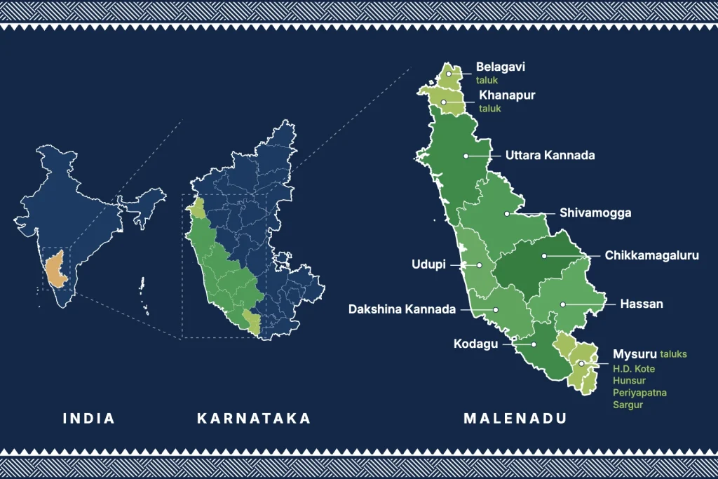
Malenadu in Karnataka (ಮಲೆನಾಡು), also spelt Malnad, Malanadu or Male Nadu, is the hill country of the state on the Western Ghats. It is the green, rain fed belt that runs from Uttara Kannada and Belagavi in the north to Kodagu in the south, between the coastal plain and the dry Deccan plateau. It is known for heavy monsoon rain, evergreen forests, waterfalls, coffee, areca and spices.
Malenadu meaning in English and Kannada
The word comes from two Kannada words: male (ಮಲೆ), meaning hill or mountain range, and nadu (ನಾಡು), meaning land or country. So Malenadu means the land of hills. In English it is written Malnad, Malenad or Malenadu.
Many people also call it the land of rain. That comes from the similar sounding word male (ಮಳೆ), which means rain in Kannada. Both fit, because Malenadu is one of the rainiest parts of India.
Where is Malenadu in Karnataka?
Karnataka is usually divided into three natural regions:
- Karavali: the narrow coastal plain of Uttara Kannada, Udupi and Dakshina Kannada.
- Malenadu: the Western Ghats and the wet hill country just east of the crest.
- Bayaluseeme: the open, drier plateau that covers most of north and east Karnataka.
Malenadu is the middle strip. Its core districts are Uttara Kannada, Shivamogga, Chikkamagaluru, Hassan and Kodagu, with the hill taluks of Udupi, Dakshina Kannada, Belagavi and Mysuru. We have put the full list with taluks and a map on our page about Malenadu districts.
Which districts are in Malenadu?
Malenadu is a region, not a single district. The districts usually counted as Malenadu in Karnataka are:
- Core Malenadu districts: Uttara Kannada, Shivamogga, Chikkamagaluru, Hassan and Kodagu.
- Foothill districts: Udupi and Dakshina Kannada, whose eastern taluks climb into the ghats.
- Hill taluks of other districts: Khanapur and Belagavi in Belagavi district, and H.D. Kote, Hunsur, Periyapatna and Sargur in Mysuru district.
See the Malenadu districts map and taluk list for the full table.
Relief features of the Malnad region
- Hills and peaks: the land is mostly 600 to 1,200 metres high, with peaks such as Mullayanagiri (1,930 m, the highest in Karnataka), Kudremukh, Baba Budangiri, Kodachadri and Tadiandamol.
- Ghats and passes: steep slopes face the sea on the west. Roads climb through passes such as Agumbe, Charmadi, Shiradi and Sampaje.
- River sources: many rivers of south India start here, including the Tunga and Bhadra (Gangamoola), Kaveri (Talakaveri), Sharavathi, Netravati and Kali.
- Valleys and waterfalls: deep valleys with paddy fields and falls such as Jog, Unchalli, Abbey and Hebbe.
- Soil: red laterite soil that drains fast and suits plantation crops.
ಮಲೆನಾಡು ಪ್ರದೇಶದ ಲಕ್ಷಣಗಳು (Features of the Malenadu region in Kannada)
For students and Kannada readers, here are the main features of the Malenadu region (malenadu pradeshada lakshanagalu) in simple Kannada.
ಮಲೆನಾಡು ಎಂದರೆ ಮಲೆಗಳ ನಾಡು, ಅಂದರೆ ಬೆಟ್ಟಗಳ ನಾಡು. ಕರ್ನಾಟಕದ ಪಶ್ಚಿಮ ಘಟ್ಟಗಳ (ಸಹ್ಯಾದ್ರಿ) ಉದ್ದಕ್ಕೂ ಹರಡಿರುವ ಈ ಪ್ರದೇಶದ ಮುಖ್ಯ ಲಕ್ಷಣಗಳು ಹೀಗಿವೆ:
- ಸ್ಥಾನ: ಮಲೆನಾಡು ಕರಾವಳಿ ಮತ್ತು ಬಯಲುಸೀಮೆಯ ನಡುವೆ, ಪಶ್ಚಿಮ ಘಟ್ಟಗಳ ಮೇಲೆ ಹಾಗೂ ಅವುಗಳ ಪೂರ್ವದ ಇಳಿಜಾರಿನಲ್ಲಿ ಇದೆ. ಉತ್ತರ ಕನ್ನಡ, ಶಿವಮೊಗ್ಗ, ಚಿಕ್ಕಮಗಳೂರು, ಹಾಸನ ಮತ್ತು ಕೊಡಗು ಮುಖ್ಯ ಮಲೆನಾಡು ಜಿಲ್ಲೆಗಳು.
- ಮಳೆ: ನೈಋತ್ಯ ಮುಂಗಾರಿನಿಂದ ಜೂನ್ನಿಂದ ಸೆಪ್ಟೆಂಬರ್ವರೆಗೆ ಇಲ್ಲಿ ಭಾರಿ ಮಳೆ ಬೀಳುತ್ತದೆ. ಆಗುಂಬೆ ಭಾರತದಲ್ಲಿ ಅತಿ ಹೆಚ್ಚು ಮಳೆ ಬೀಳುವ ಸ್ಥಳಗಳಲ್ಲಿ ಒಂದು.
- ಹವಾಮಾನ: ವರ್ಷವಿಡೀ ತಂಪಾದ ಮತ್ತು ತೇವಾಂಶವುಳ್ಳ ಹವಾಮಾನ ಇರುತ್ತದೆ.
- ಕಾಡುಗಳು: ನಿತ್ಯಹರಿದ್ವರ್ಣ ಮತ್ತು ಅರೆ ನಿತ್ಯಹರಿದ್ವರ್ಣ ದಟ್ಟ ಕಾಡುಗಳು ಇಲ್ಲಿವೆ. ತೇಗ, ಬೀಟೆ ಮತ್ತು ಹೊನ್ನೆಯಂತಹ ಬೆಲೆಬಾಳುವ ಮರಗಳು ಬೆಳೆಯುತ್ತವೆ.
- ನದಿಗಳು: ಕಾವೇರಿ (ತಲಕಾವೇರಿ), ತುಂಗಾ ಮತ್ತು ಭದ್ರಾ (ಗಂಗಾಮೂಲ), ಶರಾವತಿ ಮತ್ತು ಕಾಳಿ ನದಿಗಳು ಮಲೆನಾಡಿನಲ್ಲಿ ಹುಟ್ಟುತ್ತವೆ. ಶರಾವತಿ ನದಿಯ ಜೋಗ ಜಲಪಾತ ಇಲ್ಲಿಯೇ ಇದೆ.
- ಮಣ್ಣು: ಕೆಂಪು ಮಣ್ಣು ಮತ್ತು ಜಂಬಿಟ್ಟಿಗೆ ಮಣ್ಣು ಹೆಚ್ಚಾಗಿ ಕಾಣುತ್ತದೆ.
- ಬೆಳೆಗಳು: ಅಡಿಕೆ, ಕಾಫಿ, ಕಾಳುಮೆಣಸು, ಏಲಕ್ಕಿ, ಭತ್ತ, ತೆಂಗು ಮತ್ತು ಬಾಳೆ ಇಲ್ಲಿನ ಮುಖ್ಯ ಬೆಳೆಗಳು.
- ಜನವಸತಿ: ಹಳ್ಳಿಗಳು ಚದುರಿದಂತೆ ಇವೆ. ಮನೆಗಳು ಹೆಚ್ಚಾಗಿ ತೋಟ ಮತ್ತು ಗದ್ದೆಗಳ ನಡುವೆ ಒಂಟಿಯಾಗಿ ಇರುತ್ತವೆ.
- ವನ್ಯಜೀವಿ: ಹುಲಿ, ಆನೆ, ಸಿಂಗಳೀಕ, ಕಾಳಿಂಗ ಸರ್ಪ ಮತ್ತು ಮಂಗಟ್ಟೆ ಹಕ್ಕಿಯಂತಹ ಅಪರೂಪದ ಜೀವಿಗಳು ಇಲ್ಲಿ ಕಂಡುಬರುತ್ತವೆ.
For each of these in more detail, see our guides to the Malenadu monsoon, Malenadu crops, Malenadu wildlife and the Malenadu districts and taluks.
Why Malnad is called a biodiversity zone
Malenadu is part of the Western Ghats, which UNESCO listed as a World Heritage Site in 2012 and scientists count among the world’s biodiversity hotspots. Three things make it so rich:
- Rain: 1,500 mm on the eastern edge to more than 6,000 mm at places like Agumbe, which keeps the forests green all year.
- Many kinds of forest: evergreen and semi evergreen forest, moist deciduous forest, high grassland (shola) and sacred groves (devara kadu).
- Species found nowhere else: the lion-tailed macaque, Malabar giant squirrel, great hornbill, king cobra and hundreds of endemic plants, frogs and fish.
Protected areas such as Kudremukh, Bhadra, Nagarhole, Sharavathi Valley, Pushpagiri and the Kali Tiger Reserve guard large parts of this forest.
Rivers of Malenadu and Karnataka’s water security
The forests of Malenadu work like a sponge. They soak up the monsoon and release it slowly, so the rivers keep flowing after the rains stop. The Kaveri, Tunga, Bhadra, Hemavathi, Sharavathi, Netravati and Kali all start in these hills.
These rivers fill reservoirs such as Linganamakki, Bhadra, Hemavathi and Harangi, run hydroelectric projects at Sharavathi and on the Kali, and supply irrigation and drinking water to the Deccan plateau and the coast. Bengaluru and Mysuru drink Kaveri water that begins as rain in Kodagu. That is why the health of Malenadu matters to the whole of Karnataka.
Malenadu tourist places in Karnataka
- Agumbe (Shivamogga): rainforest, sunset point and the home of king cobra research.
- Jog Falls (Shivamogga and Uttara Kannada border): one of the highest plunge falls in India, best after the monsoon.
- Kodachadri and Sringeri: a trekking peak above Kollur, and the Sharada Peetham on the Tunga river.
- Mullayanagiri and Baba Budangiri (Chikkamagaluru): the highest peaks of Karnataka, among coffee estates.
- Kudremukh (Chikkamagaluru): rolling grassland hills and one of the best treks in the state.
- Sakleshpur and Bisle Ghat (Hassan): coffee country and a deep forest viewpoint.
- Madikeri, Abbey Falls and Talakaveri (Kodagu): Coorg, the source of the Kaveri.
- Dandeli, Yana and Sirsi (Uttara Kannada): river rafting, rock towers and the Marikamba temple.
Agriculture and livelihoods
Most families in Malenadu live from the land. Areca nut is the main cash crop, grown in shaded gardens (thota) with black pepper vines, banana, cardamom and betel leaf planted under and around the palms. Coffee estates cover the slopes of Chikkamagaluru, Hassan and Kodagu. Paddy is grown in the valley floors, and many farmers also keep bees, cows and a small sugarcane patch for jaggery.
This mixed, tree based farming has kept much of the region green. Farmer producer companies, including ours, now help small growers sell directly and get a fairer price.
Food and produce of Malenadu
Malenadu cooking is simple and seasonal. Rice is the staple, eaten with saaru and huli that are often made sour with kokum or vate huli. Akki rotti, kadubu, pathrode made with colocasia leaves, tambli and appe midi mango pickle are local favourites. Joni bella (liquid jaggery) goes on dosa and holige.
The hills grow spices such as black pepper, cardamom, clove and nutmeg, along with coffee, areca, honey and coconut. malenadu, our farmer owned company from Honnavar, brings this produce from Malenadu farmers to your home. Shop all products.
Culture, history and people
Malenadu is home to many communities, including the Havyakas, Vokkaligas, Kodavas, Gowdas, Siddis and forest dwelling tribes. Yakshagana, the night long dance drama, is performed across the region. Dollu kunitha drumming is popular around Shivamogga, and Kodagu has its own festivals such as Huttari and Kailpodh. Old village houses with tiled roofs, wooden pillars and an inner courtyard (thotti mane) are a familiar sight.
The region has a long history. The Kadambas ruled from Banavasi near Sirsi, the Hoysalas built the temples of Belur and Halebidu in Hassan district, and the Keladi Nayakas governed much of Malenadu from Keladi and Ikkeri near Sagar. Kannada writers such as Kuvempu, who grew up in Kuppalli near Thirthahalli, and Poornachandra Tejaswi wrote about Malenadu life.
Threats and conservation
Malenadu faces real pressure. Forest has been lost to dams, mines, roads and new plantations, and heavy rain on cleared slopes now brings more landslides, as seen in Kodagu in 2018. Sacred groves, community forests and protected areas help, and so does farming that keeps trees on the land. Choosing produce grown in mixed gardens rather than cleared monocultures is one small way to support the region.
Best time to visit Malenadu
October to February is the most pleasant time, with clear views and cool mornings. March to May is warm but good for estate stays. June to September brings the full monsoon: the falls are spectacular, but expect leeches, slippery paths and the occasional landslide on ghat roads.
Explore Malenadu in depth
Our guides go deeper into the places, food, farms and people of Malenadu.
Malenadu TravelMalenadu Travel GuideRoutes, stays and seasons for the rain hills
Malenadu TravelMalenadu Waterfalls22 falls with access and best season
Malenadu FoodMalenadu FoodRice, kokum, pepper and joni bella
Malenadu FoodSpices Names in Kannada80 kitchen words in English, Kannada and Hindi
Malenadu FarmingMalenadu CropsAreca, pepper, cardamom, coffee and paddy
Malenadu CultureMalenadu CulturePeople, Yakshagana, houses and festivals
ಕನ್ನಡದಲ್ಲಿಮಲೆನಾಡು: ಕನ್ನಡದಲ್ಲಿ ಮಾಹಿತಿಮಲೆನಾಡಿನ ಸರಳ ಕನ್ನಡ ಪರಿಚಯ
Malenadu TravelBangalore to MalenaduRoutes and drive times to the hills
Frequently asked questions about Malenadu
What is Malenadu?
Malenadu is the hilly, forested and rain fed region of Karnataka on the Western Ghats. It lies between the coastal belt (Karavali) and the dry plateau (Bayaluseeme) and covers districts such as Uttara Kannada, Shivamogga, Chikkamagaluru, Hassan and Kodagu.
What is Malenadu in Karnataka known for?
Malenadu is known for heavy monsoon rain, evergreen forests, waterfalls such as Jog, hill stations such as Chikkamagaluru, Sakleshpur and Coorg, and crops such as coffee, areca nut, pepper, cardamom and spices. It is also where many of Karnataka’s rivers begin.
What is Malenadu called in English?
In English it is written Malnad or Malenadu. The name means land of hills, from the Kannada words male (hill) and nadu (land).
Is Malenadu a district?
No. Malenadu is a natural region, not a district. It spreads across parts of several districts of Karnataka. See our page on Malenadu districts for the full list.
Why is Malnad identified as a biodiversity zone?
Because it is part of the Western Ghats, one of the world’s biodiversity hotspots and a UNESCO World Heritage Site. Very high rainfall, evergreen forests and many rivers support a large number of plants and animals found nowhere else, such as the lion-tailed macaque.
Which is the rainiest place in Malenadu?
Agumbe in Shivamogga district and nearby Hulikal are among the wettest places in India and usually record well over 6,000 mm of rain a year.
What is the best time to visit Malenadu?
October to February is best for sightseeing and treks. June to September is the monsoon, when waterfalls are at their fullest but roads, leeches and landslides need care.