
Malenadu districts in short: Malenadu (ಮಲೆನಾಡು), also called the Malnad region, is the hilly, rain fed belt of Karnataka along the Western Ghats. Its districts are, in effect, the Western Ghats districts of Karnataka. Its core districts are Uttara Kannada, Shivamogga, Chikkamagaluru, Hassan and Kodagu. The hill taluks of Udupi and Dakshina Kannada are usually included too, along with Khanapur and Belagavi taluks of Belagavi district and the forest taluks of Mysuru district (H.D. Kote, Hunsur, Periyapatna and Sargur).
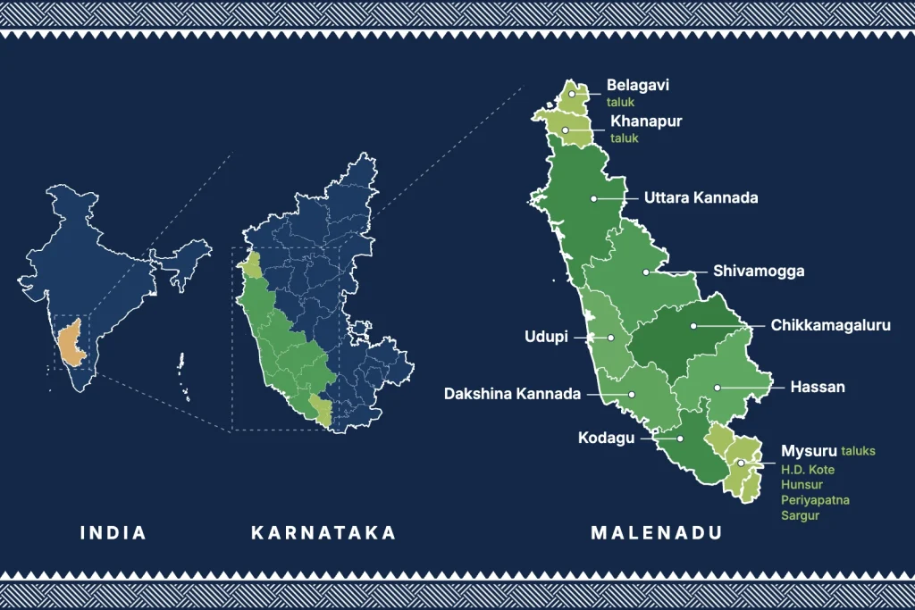
The name comes from the Kannada words male (hill) and nadu (land), so Malenadu means the land of hills. If you want to know more about the meaning, the people and the places, read our guide to Malenadu in Karnataka. This page is about the districts and taluks.
Which district is Malenadu in?
Malenadu is not one district. It is a hill region that runs through parts of nine districts of Karnataka along the Western Ghats. Five districts are almost fully Malenadu and four more have Malenadu taluks on their hilly side.
- Core Malenadu districts: Uttara Kannada, Shivamogga, Chikkamagaluru, Hassan and Kodagu.
- Districts with Malenadu taluks: Udupi and Dakshina Kannada (the foothill taluks), Belagavi (Khanapur) and Mysuru (the forest taluks near Nagarhole).
List of Malenadu districts in Karnataka (ಮಲೆನಾಡು ಜಿಲ್ಲೆಗಳು)
Malenadu is a natural region, not an administrative one, so district borders and Malenadu borders do not match exactly. Most districts below have a hilly, forested side and a drier or coastal side. The table lists the taluks that are usually counted as Malenadu.
| District | Malenadu taluks | Known for |
|---|---|---|
| Uttara Kannada | Sirsi, Siddapur, Yellapur, Joida, Haliyal, Dandeli, Mundgod (coastal taluks: Karwar, Ankola, Kumta, Honnavar, Bhatkal) | Kali Tiger Reserve, Dandeli, Yana, areca, pepper and spices |
| Shivamogga | Thirthahalli, Sagar, Hosanagara, Sorab, Shikaripura, Bhadravati, Shivamogga | Jog Falls, Agumbe, Kodachadri, areca and paddy |
| Chikkamagaluru | Mudigere, Koppa, Sringeri, N.R. Pura, Chikkamagaluru, Kadur, Tarikere | Mullayanagiri, Baba Budangiri, Kudremukh, coffee and pepper |
| Hassan | Sakleshpur, Alur, Belur, Arkalgud, Hassan | Bisle Ghat, Manjarabad Fort, coffee and cardamom |
| Kodagu (Coorg) | Madikeri, Somwarpet, Virajpet, Kushalnagar, Ponnampet | Talakaveri, Brahmagiri, coffee, pepper and honey |
| Udupi | Karkala, Hebri, Kundapura, Byndoor | Kollur, western slopes of Kudremukh, cashew and coconut |
| Dakshina Kannada | Sullia, Belthangady, Puttur, Kadaba | Kukke Subramanya, Charmadi Ghat, areca and rubber |
| Belagavi (part) | Khanapur, Belagavi | Bhimgad Wildlife Sanctuary, rice and forest produce |
| Mysuru (part) | H.D. Kote, Hunsur, Periyapatna, Sargur | Nagarhole and Kabini forests, tobacco and paddy |
Core Malenadu districts
- Uttara Kannada: the northernmost Malenadu district and the most forested district of Karnataka. Sirsi, Siddapur and Yellapur sit on the ghats while Karwar, Kumta and Honnavar are on the coast. Our own farmer producer company is based in Honnavar in this district.
- Shivamogga: often called the gateway to Malenadu. Thirthahalli, Sagar and Hosanagara are true Malenadu taluks, with Agumbe (one of the wettest places in India) and Jog Falls on the Sharavathi river.
- Chikkamagaluru: the coffee district. Mullayanagiri, the highest peak in Karnataka, and Kudremukh National Park are here. Mudigere, Koppa, Sringeri and N.R. Pura are the wettest taluks. It is also known for black pepper and cardamom.
- Hassan: the western taluks of Sakleshpur, Alur, Belur and Arkalgud are Malenadu, with coffee and cardamom estates around Bisle Ghat. The eastern part of the district is plains.
- Kodagu (Coorg): the whole district lies in the ghats. The Kaveri river rises at Talakaveri, and Kodagu is known for coffee, pepper, oranges and forest honey.
Foothill districts: Udupi and Dakshina Kannada
Both districts are mainly coastal (Karavali), but their eastern taluks climb into the Western Ghats. Karkala, Hebri, Kundapura and Byndoor in Udupi, and Sullia, Belthangady, Puttur and Kadaba in Dakshina Kannada, get very heavy rain and share the forests, farming and food of Malenadu. Kukke Subramanya, Dharmasthala and Kollur Mookambika all sit in this foothill belt.
Malenadu taluks of Belagavi and Mysuru
- Belagavi district: Khanapur taluk is the Malenadu part of Belagavi, with the Bhimgad Wildlife Sanctuary and dense forests along the Goa border. The western side of Belagavi taluk is also hilly and wet. The rest of the district is the dry Deccan plateau.
- Mysuru district: H.D. Kote, Hunsur, Periyapatna and Sargur border Kodagu and Wayanad. Nagarhole National Park and the Kabini backwaters lie here, which is why these taluks are counted with Malenadu.
Is your town in Malenadu? A quick check by taluk
Most people asking whether a place is in Malenadu want a simple yes or no. The table below gives one for the towns people ask about most, along with whether the taluk is on the list of the Malnad Area Development Board, the state body for the region.
| Town or taluk | District | Is it Malenadu? | On the board’s list? |
|---|---|---|---|
| Sirsi | Uttara Kannada | Yes, on the crest of the ghats | Yes |
| Yellapur, Siddapur, Joida, Dandeli | Uttara Kannada | Yes | Yes |
| Honnavar, Kumta, Karwar | Uttara Kannada | Coast (Karavali), with hill villages inland | Yes |
| Sagar, Thirthahalli, Hosanagara | Shivamogga | Yes, classic Malenadu | Yes |
| Shivamogga city, Bhadravati | Shivamogga | Edge of Malenadu, the gateway to the hills | Yes |
| Chikkamagaluru, Mudigere, Koppa, Sringeri | Chikkamagaluru | Yes | Yes |
| Kadur, Tarikere | Chikkamagaluru | Edge, with drier plains to the east | Yes |
| Sakleshpur, Alur, Belur | Hassan | Yes | Yes |
| Hassan city | Hassan | Edge, with plains to the east | Yes |
| Madikeri, Somwarpet, Virajpet | Kodagu | Yes, the whole district is in the ghats | Yes |
| Karkala, Hebri | Udupi | Yes, foothill Malenadu | Yes |
| Udupi city | Udupi | No, coast (Karavali) | Yes, Udupi taluk is listed |
| Sullia, Belthangady | Dakshina Kannada | Yes, foothill Malenadu | Yes |
| Mangaluru | Dakshina Kannada | No, coast (Karavali) | Yes, Mangaluru taluk is listed |
| Khanapur | Belagavi | Yes | Yes |
| H.D. Kote, Hunsur, Periyapatna | Mysuru | Forest edge, near Nagarhole and Kabini | Yes |
| Mysuru city | Mysuru | No, dry plateau | No |
| Channagiri, Honnali | Davanagere | Transition zone (Arebayalu) | Yes |
| Hangal, Hirekerur | Haveri | Transition zone (Arebayalu) | Yes |
| Dharwad, Kalghatgi | Dharwad | Transition zone (Arebayalu) | Yes |
The board’s list is wider than what most people call Malenadu. It names 74 taluks across 13 districts, including coastal taluks and drier transition taluks that get development funds. For everyday use, the 45 hill taluks in the district table above are a better guide to where Malenadu really is.
How Malenadu is defined
Geographers describe Malenadu as the strip of Karnataka that lies on the Western Ghats and the land just east of it, roughly between the coastal plain (Karavali) and the dry plateau (Bayaluseeme). Rainfall here ranges from about 1,500 mm on the eastern edge to well over 6,000 mm on the crest.
For government schemes, the Malnad Area Development Board works in selected taluks of 13 districts: Belagavi, Chamarajanagar, Chikkamagaluru, Davanagere, Dharwad, Hassan, Haveri, Kodagu, Dakshina Kannada, Mysuru, Shivamogga, Udupi and Uttara Kannada. Some of these, such as the taluks of Dharwad, Haveri and Davanagere, are a transition zone (Arebayalu) rather than true hill country, which is why most people stop at the list above.
What grows in the Malenadu districts
High rain, red laterite soil and forest cover make Malenadu farming very different from the rest of Karnataka. Most farms are small mixed gardens where areca, coconut, pepper vines, banana and spices grow together under shade trees.
- Spices: black pepper, white pepper, cardamom, clove, nutmeg and mace. Browse all of them in our Malenadu spices section.
- Plantation crops: coffee (Chikkamagaluru, Kodagu, Hassan), areca nut (Shivamogga, Uttara Kannada, Dakshina Kannada) and rubber in the foothills. See our guide to Malenadu crops for the full picture.
- Forest and garden produce: honey, kokum, vate huli (monkey jack), jackfruit and arrowroot.
- Food crops: paddy in the valleys, sugarcane for jaggery, and coconut for wood pressed coconut oil.
malenadu (the brand, written in lowercase) is a farmer owned company from Honnavar that brings natural produce from these hills to your home. You can read our story on the About page.
Protected forests in the Malenadu districts
- Kali Tiger Reserve (Dandeli and Anshi) in Uttara Kannada
- Sharavathi Valley and Shettihalli sanctuaries in Shivamogga
- Bhadra Tiger Reserve and Kudremukh National Park in Chikkamagaluru
- Pushpagiri, Brahmagiri and Talakaveri sanctuaries in Kodagu
- Mookambika and Someshwara sanctuaries in Udupi
- Bhimgad Wildlife Sanctuary in Khanapur, Belagavi
- Nagarhole National Park in Kodagu and Mysuru
These forests are home to the lion-tailed macaque, Malabar giant squirrel, king cobra, great hornbill and many plants found nowhere else. Sacred groves (devara kadu) kept by villages add hundreds of small protected patches between them.
Frequently asked questions about Malenadu districts
Which districts are in Malenadu?
The core Malenadu districts are Uttara Kannada, Shivamogga, Chikkamagaluru, Hassan and Kodagu. Udupi and Dakshina Kannada are usually added for their hill taluks at the foot of the Western Ghats, along with Khanapur and Belagavi taluks of Belagavi district and H.D. Kote, Hunsur, Periyapatna and Sargur taluks of Mysuru district.
How many districts are in Malenadu?
There is no single official number. Seven districts are commonly called Malenadu. For development funds, the Karnataka government’s Malnad Area Development Board covers taluks in 13 districts, including some drier transition taluks.
Is Hassan a Malenadu district?
Yes. The western taluks of Hassan, mainly Sakleshpur, Alur, Belur and Arkalgud, are classic Malenadu country with coffee estates and heavy rain. The eastern side of the district is drier plains.
Is Sirsi in Malenadu?
Yes. Sirsi in Uttara Kannada is one of the best known Malenadu towns, along with Siddapur and Yellapur. It sits on the crest of the Western Ghats and is famous for areca, pepper and spice gardens.
Is Shivamogga called the gateway to Malenadu?
Yes. Shivamogga city is often called the gateway to Malenadu because the road to Thirthahalli, Agumbe, Sagar and Jog Falls starts there.
Are Udupi and Mangaluru part of Malenadu?
The coastal towns of Udupi and Mangaluru are part of Karavali, the coastal belt. The eastern taluks of these districts, such as Karkala, Hebri, Sullia and Belthangady, rise into the ghats and are counted as Malenadu.
What is Malenadu called in Kannada and English?
In Kannada it is ಮಲೆನಾಡು (Malenadu), meaning land of hills. In English it is usually written Malnad or Malenadu.
Is Chikkamagaluru in Malenadu?
Yes. Chikkamagaluru is one of the core Malenadu districts. Mudigere, Koppa, Sringeri, N.R. Pura and the country around Chikkamagaluru town are hill taluks, while Kadur and Tarikere run down into drier plains.
Is Sagar in Malenadu?
Yes. Sagar in Shivamogga district is a classic Malenadu taluk, with heavy rain, areca gardens and Jog Falls nearby. Thirthahalli and Hosanagara around it are Malenadu too.
Is Kodagu (Coorg) part of Malenadu?
Yes. The whole of Kodagu lies in the Western Ghats, so every taluk of the district, from Madikeri to Virajpet, is counted as Malenadu.
Is Mysuru part of Malenadu?
Mysuru city is not. It sits on the dry plateau. The forest taluks of the district near Nagarhole and Kabini, such as H.D. Kote, Hunsur, Periyapatna and Sargur, are counted with Malenadu.
Is Belagavi in Malenadu?
Only its western edge. Khanapur taluk, with the Bhimgad forests along the Goa border, is Malenadu. Most of Belagavi district is the dry Deccan plateau.
Is Davanagere a Malenadu district?
No. Davanagere is mostly plains. Its Channagiri, Honnali and Nyamathi taluks are on the Malnad Area Development Board list as a transition zone, not true hill country.
How many taluks are in Malenadu?
There is no single official count. The Malnad Area Development Board lists 74 taluks across 13 districts, but the hill taluks most people call Malenadu number about 45, as listed in the table on this page.